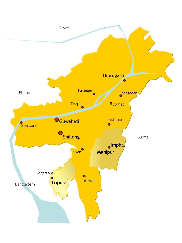
The North Eastern part of India which comprises Assam, Arunachal Pradesh, Meghalaya, Nagaland, Manipur, Mizoram,Tripura and Sikkim is situated on the foothills of the eastern ridge of the Himalayan mountain range. This area is gifted with picturesque natural landscape,moribund flora and fauna and above all diverse ethnicity.Its lush green natural landscape has always been a point of fascination for tourists all around the world.The north east india in all its aspects, whatever it may be culturally,ethnically,linguistically is distinct from the rest of india. It has cultural affinity to the south asian countries especially Mongolia,Myanmar, Thailand, Taiwan, and Tibet. Linguistically most of the north eastern region accept Assam and Tripura has predominance of TIbeto- Burmese language group. Anthropologically the peoples of north east belongs to the mongoloid racial group.
It is officially recognized that the eight states form a special category: the North Eastern Council (NEC) was constituted in 1971 as the nodal agency for the economic and social development of the eight states, the North Eastern Development Finance Corporation Ltd (NEDFi) was incorporated on August 9, 1995 and the Ministry of Development of Northeastern Region (DONER) was set up in September 2001. Among the North Eastern states, Sikkim became an Indian protectorate in 1947 and a full state in 1975. The Siliguri Corridor in West Bengal, with an average width of 21 km to 40 km, connects the north eastern region with the rest of India. More than 2000 km of boundary is shared with other countries: including Nepal, China, Bhutan, Burma and Bangladesh.
 HISTORY
After the Indian Independence
from British Rule in 1947, the Northeastern region of British India consisted
of Assam and the princely states of Manipur and Tripura. Later independent
movements such as Swatantra Tripura Committee were formed against grouping all
the north eastern states under Assam. The states of Nagaland, Meghalaya and
Mizoram were formed in the 1960-70s. From Shillong, the capital of Assam was
shifted to Dispur, now a part of Guwahati. Shillong became the capital of
Meghalaya. Most of these areas had been incorporated into mainstream India
during the British Raj when colonial authorities annexed traditionally separate
border states into Indian territory to form a buffer between their colony and
external powers (i.e.: Assam, Manipur and Tripura in the Northeast, and
Balochistan and the North West Frontier Province in the northwest). After
independence in 1947, extension of the Indian state and political apparatus has
been a challenge.
The region is known for its unique culture, handicrafts,
martial arts, and scenic beauty.
GEOGRAPHY
CLIMATE
Northeast India has a predominantly humid sub-tropical climate with hot, humid summers, severe monsoons and mild winters. Along with the west coast of India, this region has some of the Indian sub-continent's last remaining rain forests. The states of Arunachal Pradesh and Sikkim have a mountain climate with cold, snowy winters and mild summers.
MOUNTAIN
RANGE
THE EASTERN HIMALAYA:
The Eastern Himalaya mountain ranges covers an
area of 121,300 square kilometers (46,800 sq mi), extending along the
north and south faces of the Himalaya Range from the Kali Gandaki Gorge in central Nepal eastwards through Tibet , Bhutan, India's Sikkim state ( including Darjeeling ,WB),Seven
sister and northern most Myanmar.The altitude between approximately 4,000 and 5,500 meters
(13,000 and 18,000 ft) elevation. Permanent ice and snow lies above 5,500
meters (18,000 ft). The Eastern Himalayan sub alpine
conifer forests lie
below 3,000 meters (9,800 ft) along the southern slopes of the range, from
Central Nepal to Bhutan. The Northeastern range in Arunachal Pradesh, extending north of
the range into the lower valley of the Brahmaputra
River and its tributaries.
THE PATKAI RANGE:
The Patkai or Purvanchal, are situated near India's eastern border with
Myanmar. They were created by the same tectonic processes which led to the
formation of the Himalayas. The physical features of the Patkai mountains are
conical peaks, steep slopes and deep valleys. The Patkai ranges are not as
rugged or tall as the Himalayas. There are three hill ranges that come under
the Patkai: the Patkai–Bum, the Garo–Khasi–Jaintia and the Lushai hills. The
Garo–Khasi range lies in Meghalaya. Mawsynram, a village near Cherrapunji lying
on the windward side of these hills, has the distinction of being the wettest
place in the world, receiving the highest annual rainfall.
WATER BODIES:
RIVERS
THE BRAHMAPUTRA
:The Brahmaputra also called Tsangpo-Brahmaputra, is a trans-boundary river and
one of the major rivers of Asia. It is the only Indian river that is attributed
the masculine gender and thus referred to as a nada in Indo-Aryan languages and
languages with Indo-Aryan influence. All other Indian rivers are referred to as
'nadī.From its origin in southwestern Tibet as the Yarlung
Tsangpo River, it flows across southern Tibet to break through the Himalayas in
great gorges and into Arunachal Pradesh (India) where it is known as Dihang. It
flows southwest through the Assam Valley as Brahmaputra and south through
Bangladesh as the Jamuna (not to be mistaken with Yamuna of India). In the vast
Ganges Delta it merges with the Padma, the main distributary of the Ganges,
then the Meghna, before emptying into the Bay of Bengal.
About 1,800 miles (2,900
km) long, the Brahmaputra is an important river for irrigation and
transportation. The average depth of the river is 124 feet (38 m) and maximum
depth is 380 feet (120 m). The river is prone to catastrophic flooding in
spring when the Himalayan snows melt. The average discharge of the river is
about 19,300 cubic metres per second (680,000 cu ft/s), and floods can reach
over 100,000 cubic metres per second (3,500,000 cu ft/s).It is a classic
example of a braided river and is highly susceptible to channel migration and
avulsion.It is also one of the few rivers in the world that exhibit a tidal
bore. It is navigable for most of its length.
The Brahmaputra's upper
course was long unknown, and its identity with the Yarlung Tsangpo was only
established by exploration in 1884-86. This river is often called
Tsangpo-Brahmaputra river.The lower reaches are sacred to Hindus. While most
rivers on the Indian subcontinent have female names, this river has a rare male
name, as it means "son of Brahma" in Sanskrit (putra means
"son").
The Brahmaputra enters
India in the state of Arunachal Pradesh, where it is called Siang. It makes a
very rapid descent from its original height in Tibet, and finally appears in
the plains, where it is called Dihang. It flows for about 35 kilometres (22 mi)
and is joined by the Dibang River and the Lohit River at the head of the Assam
Valley. Below the Lohit the river is called Brahmaputra, enters the state of
Assam and becomes very wide—as wide as 10 kilometres (6.2 mi) in parts of
Assam. It is joined in Sonitpur by the Kameng River (or Jia Bhoreli).Between
Dibrugarh and Lakhimpur districts the river divides into two channels—the
northern Kherkutia channel and the southern Brahmaputra channel. The two
channels join again about 100 kilometres (62 mi) downstream forming the Majuli
island, the largest river island in India. At Guwahati, near the ancient
pilgrimage center of Hajo, the Brahmaputra cuts through the rocks of the
Shillong Plateau, and is at its narrowest at 1 kilometre (1,100 yd)
bank-to-bank. Due to the river's narrow width, the Battle of Saraighat was
fought here. The first rail-cum-road bridge[clarification needed] across the
Brahmaputra was opened to traffic in April 1962 at Saraighat.
The
environment of the Brahmaputra floodplains in Assam have been described as the
Brahmaputra Valley semi-evergreen forests ecoregion
THE BARAK RIVER:The
Barak River is one of the major rivers of southern Assam and is a part of the
Surma-Meghna River System. It is the biggest and the most important of all the
rivers in the Manipur hill territory, from where it originates. From its source
in the Manipur Hills of India, near Mao Songsang, the river is known as the
Barak River. Near its source, the river receives a lot of little hill streams,
including the Gumti, Howrah, Kagni, Senai Buri, Hari Mangal, Kakrai, Kurulia,
Balujhuri, Shonaichhari and Durduria. It flows west through Manipur State, then
southwest leaving Manipur and entering Mizoram State.In Mizoram State the Barak
flows southwest then veers abruptly north when joined by a north flowing stream
and flows into Assam State where it turns westward again near Lakhipur as it
enters the plains. It then flows west past the town of Silchar where it is
joined by the Madhura River. After Silchar, it flows for about 30-odd
kilometres & near Badarpur, it divides itself into the Surma River and the
Kushiyara River and enters Bangladesh. The principal tributaries of the Barak
in India are the Jiri, the Dhaleshwari (Tlawng), the Singla, the Longai, the
Madhura, the Sonai (Tuirial), the Rukni and the Katakhal.
The depth of river is 15 feet (0.0013
h). 60 hours (710,000 ft) 100 feet (0.0085 h) 90 feet (0.0076 h) 85 feet
(0.0072 h
LAKES
 |
| LOKTAK LAKE |
COMMUNITIES
These are the main communities of north east india:
Assamese, Bengali, Bishnupriya Manipuri , Chakma, Bodo, Dimasa, Garo, Karbi ,Khasi, Kuki, Meitei people, Mizo, Naga, Rabha, Koch Rajbongshi, Mishing, Sylheti, Tiwa, Nepali, Hmar, Zeme Naga, Adivasi.
This comment has been removed by the author.
ReplyDeleteThis comment has been removed by the author.
ReplyDelete